Birmania Fm
Type Locality and Naming
OUTCROP. Exposure near Birmania Village. Besides, the outcrops can be seen along the track from Lakha to Birmania. The formation is also present in shallow tube-well sections near Jhininiali village. [Original Publication: Narayanan , K. 1959. Progress report on the geological work in Jaisalmer, ONGC report (Unpublished)]
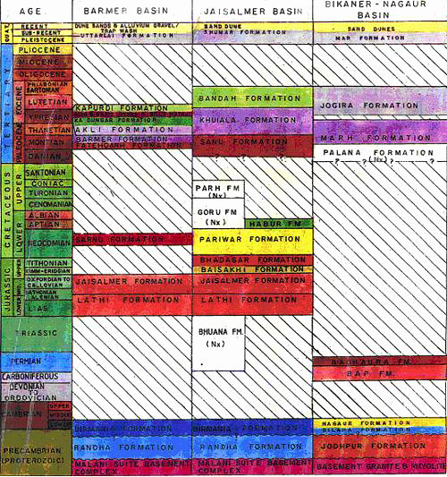
Synonyms: Narayanan mapped the Cherty Limestone and Shales of the Birmania Formation along with clastic sequence at its lower part, which was later identified by Misra and Shrivatasava (1960) as Randha Fm.
Lithology and Thickness
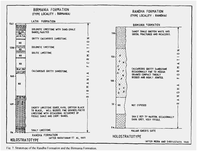
Siliceous limestone. The formation is mainly a carbonate sequence of grey, cherty and dolomitic limestone with interbeds of shale and calcareous sandstone (Fig 7). In the type section, the formation is composed of limestone and gritty calcareous sandstone. The cherty limestone is dense, hard, grey to black, well-bedded fine-grained. The associated shales are very fissile, dark grey and form fairly persistent beds. At places dolomitic and oolitic limestone bands are also noticed. The upper part of the formation gets partly dolomitized. Around 2000 m thickness including dolomitic and oolitic limestone bands are observed.
[Figure 1: Stratotype of Birmania Formation, Mesozoic Lithostratigraphy of the Jaisalmer Basin, Rajasthan, Journal of the Paleontological Society of India, Vol. 51(2) (after Singh N.P, 2006)]
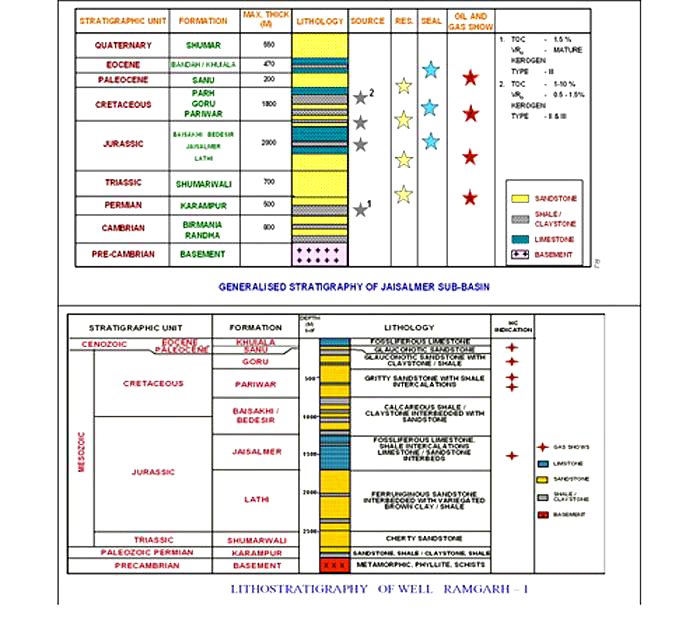
[Figure 2: Generalized and Subsurface Stratigraphy of Jaisalmer Basin (from dghindia.gov.in)]
Relationships and Distribution
Lower contact
The formation unconformably overlies Randha Fm in the type area but southwest of Birmania Village it directly overlies at the basement (Rhyolite/Granite).
Upper contact
Formation's upper boundary is unconformable with the overlying Lathi Fm (Narayanan et al., 1961). However, Dhar and Mehta (1974) reported that Cenozoic sediments directly overly the Birmania Formation with an angular unconformity east of Birmania.
GeoJSON
Fossils
Age
Depositional setting
The lithological association of dark grey shale, and dense, dark grey, cherty limestone with interbedded chert is indicative of the deposition in a marine setting.
Additional Information


